Google Maps eases transit of wheelchair-bound commuters
Feature has been rolled out in London, New York, Tokyo, Mexico City, Boston, and Sydney
Published March 16, 2018

To provide relief to wheelchair-bound commuters, Google Maps has introduced a new feature to help transit of people with mobility needs.
The feature helps people in identifying all the “wheelchair” accessible routes in major metropolitan transit centres around the world such as London, New York, Tokyo, Mexico City, Boston, and Sydney.
“We're looking forward to working with additional transit agencies in the coming months to bring more wheelchair accessible routes to Google Maps,” Rio Akasaka, product manager Google Maps, said in a blog post on Friday.
“Google Maps was built to help people navigate and explore the world, providing directions, worldwide, to people traveling by car, bicycle or on foot. But in city centers, buses and trains are often the best way to get around, which presents a challenge for people who use wheelchairs or with other mobility needs,” reads the blog post.
To access the “wheelchair accessible” routes, users should enter their desired destination into Google Maps. Tap "Directions” then select the public transportation icon. Then tap “Options” and under the Routes section, you’ll find “wheelchair accessible” as a new route type.
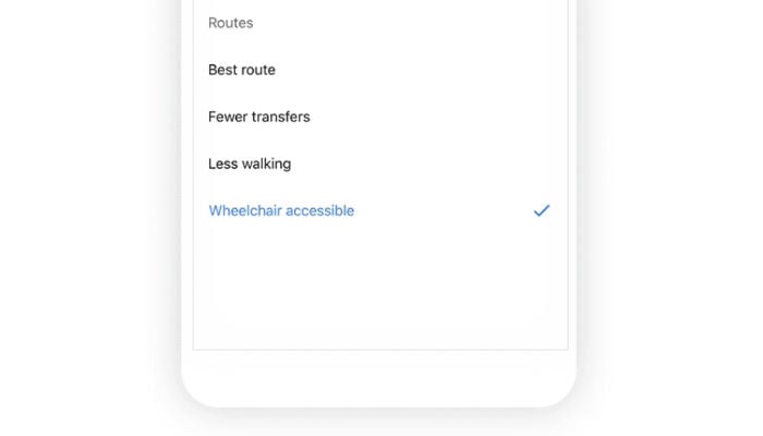
Selecting the option, will show people a list of possible routes that take mobility needs into consideration.
"We built this feature to make life easier for people who use wheelchairs, but accessible routes are also helpful if you’re on crutches or pushing a stroller. With the help of transit agencies around the globe and people like you who contribute local knowledge, we’re making progress toward a more accessible world for everyone," states the blog post.


