When is Europe's ERS-2 satellite reentering Earth?
Some of the parts of the satellite would break and burn up outside the atmosphere, the space officials say
February 20, 2024
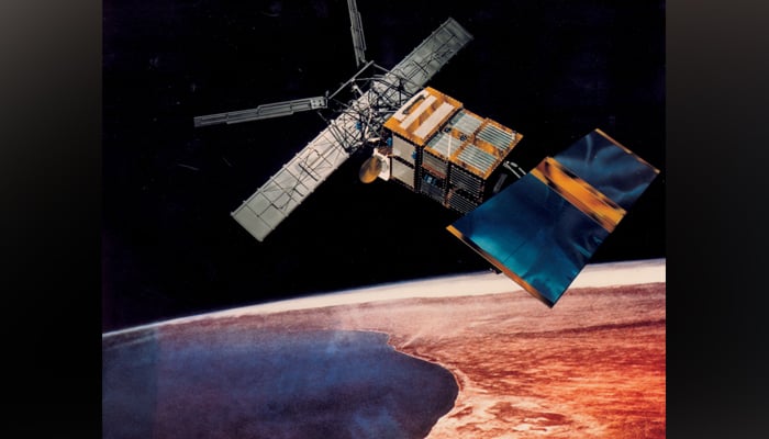
A satellite developed by Europe in the late 20th century to collect data from space regarding the Earth's surface, oceans, and polar caps in making its reentry into the planet's atmosphere.
According to a statement from the European Space Agency (ESA), its European Remote Sensing (ERS-2) satellite was likely to reenter Wednesday morning, however, experts are unclear when exactly it would hit the atmosphere due to multiple factors affecting its pace.
Some of the parts of the satellite would break and burn up outside the atmosphere, the space officials noted.
The ESA's space debris office is tracking the ERS-2 which was launched into space in April 1995, CNN reported.
However, the agency also highlighted the window of 15-hour uncertainty.
The statement from ESA noted: "As the spacecraft’s reentry is ‘natural’, without the possibility to perform manoeuvers, it is impossible to know exactly where and when it will reenter the atmosphere and begin to burn up."
The ambiguity of reentry is because of the density of the Earth's atmosphere which would become dense due to solar activity.
Solar activity has been increasing as the sun is nearing its 11-year-cycle peak — solar maximum.
The satellite weighs around 5,057 pounds (2,294 kilograms) after fuel depletion, becoming similar in size to other space debris that makes entry into Earth’s atmosphere every week, the agency said.
Some of the components of the ERS-2 may reach Earth’s surface, however, there is no harm as they would fall into the ocean.
ERS-2 was the first-ever modern satellite by Europe in the late 20th century developed to observe the Earth.
The satellite, accompanied by similar ERS-1 acquired crucial information on the Earth’s polar caps, surface, and oceans. It also acquired data on floods and disasters in remote areas of the earth.
Its data still holds value.
The agency in 2011 decided to decommission the satellite and deorbit it.
The deorbiting activities in 2011 caused fuel depletion and decreased its altitude, setting ERS-2's orbit on a path to slow spiral closer to Earth and make entry into its atmosphere within 15 years.


