'Extremely dangerous' Hurricane Idalia makes landfall on Florida's Big Bend
Hurricane Idalia's most dangerous feature would be a powerful surge of wind-driven surf, say officials
August 30, 2023
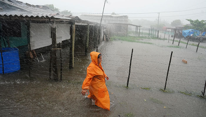
Hurricane Idalia made landfall in Florida as an "extremely dangerous" Category 3 hurricane on Wednesday, after millions of inhabitants fled their homes taking refuge in shelters due to fears of a potentially fatal storm surge.
Drawing strength from the Gulf of Mexico's warm waters, Idalia unleashed destructive winds and torrential downpours that were forecast to cause coastal flooding up to 16 feet (4.88 m) deep along the state's Gulf Coast.
Idalia came ashore at 7:45am (1145 GMT) at Keaton Beach, an ocean-front community of 13,000 people in Taylor County, about 75 miles (121 km) southeast of Tallahassee, the state capital. The town lies in the center of the Big Bend region, where the state's northern panhandle curves into the Florida Peninsula.
"It's just ripping through Taylor County now. Hope all is safe," County Commissioner Jamie English told Reuters. "Winds gusting. Terrible power outages all over. Debris flying everywhere."
Video footage from Keaton Beach posted on social media platform X by storm chaser Sidney Grimmett showed heavy downpours and trees whipping in the wind as an electrical line sparked along the side of a roadway.
Overnight, attained "an extremely dangerous Category 4 intensity" on the five-step Saffir-Simpson wind scale on its way to landfall in Florida Wednesday morning, the National Hurricane Center (NHC) in Miami said.
But by 7am (1100 GMT) it weakened slightly, slipping into Category 3, with maximum sustained winds of 125mph (201km). Any storm reaching Category 3 or higher is considered a major hurricane.
Sparsely populated compared with the Tampa-St. Petersburg area to the south, the Big Bend features a marshy coast, threaded with freshwater springs and rivers, and a cluster of small offshore islands forming Cedar Key, a historic fishing village demolished in 1896 by a hurricane's storm surge.
Early Wednesday morning, storm winds were knocking bent palm tree tops against Ken Wood's house in Dunedin, near Tampa and 185 miles south of landfall.
Wood, 57, a bridge tender in Pinellas County, did not heed evacuation orders even after he shut down the bridge between on the Dunedin Causeway on Tuesday, saying he figured he was on high enough ground.
"Mainly it's a lot of loud wind and rain right now, some thunder," he told Reuters by telephone, adding that roads were flooded. "The sky is dark."
Most of Florida's 21 million residents, and many in the adjacent states of Georgia and South Carolina, were under hurricane warnings and other storm-related advisories. State emergency declarations were issued in all three.
Florida's Gulf Coast, southeastern Georgia and eastern parts of North and South Carolina could face 4 to 8 inches (10 to 20 cm) of rain through Thursday, with isolated areas seeing as much as a foot of rain (30 cm), the hurricane centre warned.
Officials said the storm's most dangerous feature would be a powerful surge of wind-driven surf that is expected to flood barrier islands and other low-lying areas along the coast.


