NASA satellite to map soil moisture poised for launch
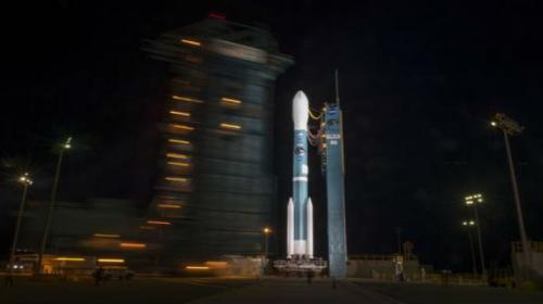
CAPE CANAVERAL: An unmanned Delta 2 rocket is being prepared for launch on Saturday to put a NASA satellite into orbit that is expected to improve drought monitoring and flooding forecasts.The...
January 31, 2015

The 127-foot-tall (39-metre) rocket, built and flown by United Launch Alliance, is scheduled to lift off from Vandenberg Air Force Base in California at 6:20 a.m. PST (1420 GMT).
Launch originally was planned for Thursday but was delayed 24 hours due to high winds, the National Aeronautics and Space Administration said.
United Launch Alliance, a partnership of Lockheed Martin and Boeing, postponed the flight for one more day so that technicians could repair insulation on the rocket that had become detached during Thursday’s launch attempt.
Perched on top of the rocket is NASA’s Soil Moisture Active Passive observatory, or SMAP, which is to spend at least three years making precise measurements of the amount of water in Earth’s topsoil.
Soil moisture accounts for less than 1 percent of the planet’s total water reservoir, with 97 percent in the Earth's oceans and nearly all of the rest locked in ice, said SMAP lead scientist Dara Entekhabi of the Massachusetts Institute of Technology.
But the tiny amount of soil moisture links the planet’s overall environmental systems, its water, energy and carbon cycles, as well as determines whether particular regions are hit by drought or flooding. “It’s the metabolism of the system,” Entekhabi said during a prelaunch news conference.
Currently, scientists rely largely on computer models to account for soil moisture. SMAP is designed to provide hard numbers of the amount of water in the soil and to do so worldwide, every two to three days.
The launch, 2,100-pound (950-kg) spacecraft and three years of operations is costing NASA $916 million.


