Cyclone Biparjoy live updates: Storm weakens as it gets closer to Pakistan, India
Authorities in Pakistan and India remain on high alert, evacuations underway in coastal areas
Published June 13, 2023
Tropical cyclone Biparjoy weakened into a Very Severe Cyclonic Storm (VSCS) from an Extremely Severe Cyclonic Storm (ESCS) while moving further north-northwestward during the last 6 hours, as it inched closer to the coast of Pakistan and India.
As per the latest forecast, the cyclone is likely to move nearly northwards till tomorrow morning (June 14) and then recurve north-northeastwards and cross Keti Bandar (southeast Sindh) adjoining Indian coasts between Karachi and Gujarat, India, by the evening of June 15 as a VSCS.
According to latest update issued by the Pakistan Meteorological Department (PMD), Biparjoy is currently located near latitude 21.2°N and longitude 66.6°E at a distance of about 410km south of Karachi, 400km south of Thatta, about 300km west-southwest of Porbandar, 290km southwest of Devbhumi Dwarka, 340km south-southwest of Jakhau Port and 350km south-southwest of Naliya.
The authorities in the coastal areas of both countries have been advised to stay on high alert. Efforts to evacuate thousands of residents are underway as the cyclone inches closer.
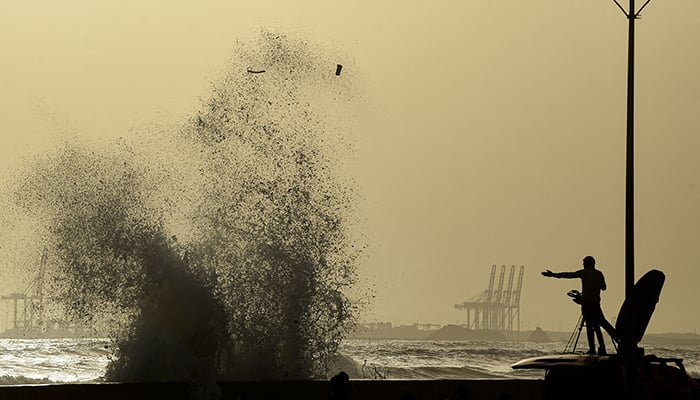
Fishermen are advised not to venture into the open sea till the system is over by 17 June, as the sea level has started to rise along the coastal belt and the Arabian Sea conditions may get very rough/high.
Read live coverage of cyclone Biparjoy here
Possible impacts on Pakistani coastal areas:
— Widespread wind-dust/thunderstorm rain with some very heavy/extremely heavy falls accompanied by squally winds of 80-100 kilometre per hour gusting 120kmph likely in Thatta, Sujawal, Badin, Tharparker, Mirpurkhas and Umerkot districts from June 13 to 17.
— Dust/thunderstorm-rain with few heavy falls, accompanied by squally winds of 60-80kmph likely in Karachi, Hyderabad, Tando Muhammad Khan, Tando Allayar, Shaheed Benazirabad and Sanghar districts from 14 -16 June.
— Squally (high intensity) winds may cause damage to loose and vulnerable structures (Kutcha houses) including solar panels etc.
— Storm surge of 3-3.5 meters (8-12 feet) expected at the land falling point (Keti Bandar and around) which can inundate the low-lying settlements.
Possible impacts on Indian coastal areas:
— Light to moderate rainfall at many places in the coastal districts of Saurashtra and Kutch with isolated heavy to very heavy rainfall on June 13.
— Light to moderate rainfall at most places with heavy to very heavy rainfall and extremely heavy falls at isolated places very likely over Kutch, Devbhumi Dwarka, Porbandar, Jamnagar, Rajkot, Junagarh and Morbi districts of Saurashtra and Kutch on June 14
— The intensity of rainfall would increase with heavy to very heavy rainfall at a few places and extremely heavy falls at isolated places very likely over Kutch, Devbhumi Dwarka and Jamnagar and heavy to very heavy rainfall at a few places over Porbandar, Rajkot, Morbi and Junagarh districts of Gujarat and Isolated heavy to very heavy rainfall is very likely over remaining districts of Saurashtra and north Gujarat region on 15th June.
— Light to moderate rainfall at most places with heavy to very heavy rainfall at isolated places very likely over north Gujarat and adjoining south Rajasthan on June June 16.
Key updates on cyclone:
Biparjoy only 380km south of Karachi
How dangerous is Biparjoy?
Massive evacuation underway at Keti Bandar
A massive level evacuation is underway at the Keti Bandar area in Thatta District, and a large number of people have been shifted to safer places.
"Evacuation continues from Keti Bandar and the islands due to possible hurricane," Deputy Commissioner Farooq Soomro said, sharing an update on the progress of bringing people to safe locations.
He said that victims have been shifted to relief camps set up in schools of Keti Bandar and Baghan.
Army deployed
Instructions have been issued to all garrisons of the Pakistan Army regarding public assistance and rescue missions on an emergency basis.
Fresh troops of the Pakistan Army have been dispatched from Hyderabad, Badin and Malir cantts to help the civil administration in evacuating vulnerable populations from the coastal belt.
Moreover, all garrisons of Karachi Corps have been readied for all kinds of relief activities and management of affected people.
Coastal areas of Thatta facing extreme heat
"The sea is cloudy, very hot and humid. Other areas, including Keti Bandar are experiencing extreme heat and humidity," he said.
The DC further shared that the meteorological department has predicted rain in the coastal belt afternoon.
Seawater submerges affected areas
Among the affected areas is Chashma Goth, where seawater continues to increase and has reached roadsides. However, residents have not vacated their homes yet.
Moreover, fishermen at the Rehri Goth jetty have said that the water level at the jetty is increasing, submerging some parts of the jetty in the evening hours.


