Pakistan remains in the eye of rainstorms as Met forecasts more downpours
Meteorological Centre Balochistan advises relevant authorities to remain vigilant during next 36 to 48 hours
April 18, 2024
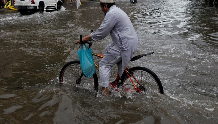
QUETTA/PESHAWAR: Rainstorms are coming down crashing on Pakistan, especially in parts of Balochistan and Khyber Pakhtunkhwa (KP), causing flash floods, infrastructural damage, and loss of life, bringing whole towns to a swamping halt amid a forecast of more torrents in the weeks to come.
According to official estimates, until April 17, over 65 people succumbed to weather-related incidents including lightning across Pakistan, with rain so far in April falling at nearly twice the historical average rate; however, this death toll is expected to rise.
Torrential rainfall continued to wreak havoc in Balochistan, lashing its several districts over the past few days, with landslides and floods.
As a result of heavy rains floodwaters entered the town of Chaman, sweeping away a car and resulting in the loss of five lives. So intense were the flashfloods that Quetta-Chaman highway continues to be submerged at several locations, disrupting the transportation.
Issuing high alert, authorities declared emergency in hospitals. The wrath of rain was not restricted to the mainland as one hundred fishing boats were reported to have been damaged dealing millions of rupees of losses to the fishermen. The flooding was also reported in rural areas of Mardan.
Moreover, the bridge over the Basol River on the Makran Coastal Highway collapsed, cutting off land communication between Gwadar and Makran with Karachi.
National highways in Hernai remained blocked and heavy traffic could not be restored even after six days, while train services on the Hernai-Sibi railway section have been suspended for the last four days.
In the rural areas of Balochistan, several orchards of apricot, pomegranate, grapes, and apples and farms of onions, and wheat were also laid waste to by the swamping floodwaters.
The National Disaster Management Authority (NDMA) as per the latest projections from the National Emergency Operations Centre (NEOC) and multiple weather models, in its latest advisory highlighted a series of moderate to intense weather systems that could cause rainfall and thunderstorms in the country from April 17th to 29th.
"These weather patterns are anticipated to bring heavy rain, thunderstorms, and hailstorms, posing significant risks to various parts across the country," said the NDMA news release issued here Wednesday.
The forecast indicated that a weather system would enter Pakistan on April 17th, initiating a period of heavy rainfall and thunderstorms lasting until April 22nd.
Meanwhile, the Regional Meteorological Center of Balochistan has forecast very heavy rain and thundershowers at some places in Gwadar (Jiwani, Pasni), Kech (Turbat), Awaran, Chagi, Panjgur, Kharan, Washuk and Noshki districts during the next 24 hours.
The Meteorological Centre Balochistan has advised the relevant authorities to remain vigilant during the next 36 to 48 hours.
Rain and thunderstorms are expected in Gwadar, Kech (Turbat), Awaran, Chagi, Kharan, Pasni, Ormara, Lasbela, Khuzdar, Kalat, Noshki, Jhal Magsi, Nasirabad, Sibi, Kohlu, Dera Bugti, Loralai and Harnai on Thursday.
The Met Office has forecast rain with wind and thundershowers in Quetta, Ziarat, Chaman, Pishin, Musakhel and Barkhan during the next 24 hours.
According to the NDMA advisory, Upper Punjab will experience the effects from April 18th to April 21st, while KP, Gilgit Baltistan (GB), and Azad Jammu and Kashmir (AJK) will be affected from April 17th to 22nd April," the advisory said.
Following this, a weaker weather system was expected to enter Pakistan on April 23rd, bringing low rainfall and thunderstorms to certain parts of the country until April 24th.
However, Sindh was not expected to be impacted during this period.
Subsequently, a strong weather system is forecasted to enter Pakistan on April 25th, bringing heavy rain, thunderstorms, and hailstorms with occasional gaps until April 29th.
This system will affect Balochistan from April 25th to April 29th, with intermittent gaps.
Sindh will experience impacts on April 25th, 26th, and 28th, while South Punjab will be affected from April 27th to April 28th.
Upper Punjab will face the brunt from April 26th to April 29th, while KP will experience effects from 25th to 29th April, potentially impacting GB and AJK from April 25th to April 29th.
The expected rainfall may trigger flash floods in local nullahs of vulnerable areas, including Khuzdar, Ziarat, Zhob, Sherani, Muslim Bagh, Quetta, Pishin, Kech, Panjgur, Gwadar, and Turbat.
Flooding may also occur in low-lying areas during the forecast period, particularly in southern western Balochistan.
In light of these projections, the National Disaster Management Authority (NDMA) has issued instructions for Provincial Disaster Management Authorities (PDMAs), District Disaster Management Authorities (DDMAs), and other relevant line departments to remain vigilant and prepared to respond to any emergent situations.


