Rise in mild Karachi earthquakes prompts calls for disaster preparedness
The city’s building codes need enforcing, and the groundwater extraction that destabilises buildings needs controlling, say experts
Published December 04, 2025
In June, consecutive tremors shook Pakistan’s largest city, Karachi. Fifty-seven low-intensity quakes, measuring 1.5-3.8 on the Richter scale, were recorded on 1-25 June, the Pakistan Meteorological Department (PMD) reportedly said. Several months later, October began with a 3.2-magnitude quake in Malir, a neighbourhood in the city’s north.
Karachi sits near the boundaries of three major tectonic plates and multiple fault lines run through the city. Some 49 earthquakes with a magnitude of four or above have struck within 300 km of Karachi in the last decade.
Mild quakes can sometimes act as “natural pressure releases, potentially reducing the risk of more destructive ones”, but the frequency of these earthquakes has raised concerns among experts, said geological oceanographer and former director of the Geological Survey of Pakistan, Asif Rana.
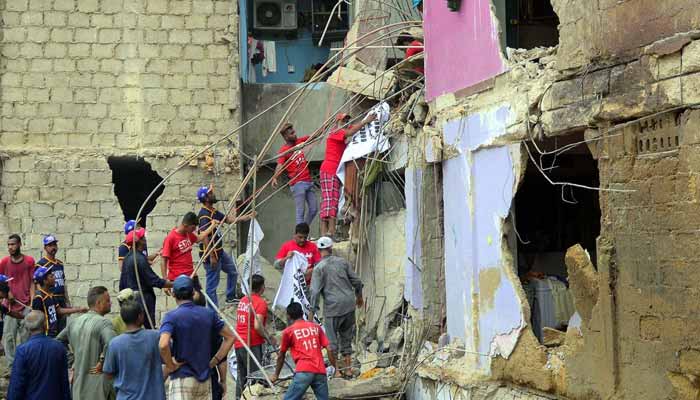
In Karachi, mild quakes can have potentially devastating impacts on buildings that lack structural integrity. The Association of Builders and Developers stated in July that some 700 buildings have been identified in the city as not stable enough for safe habitation. This was shortly after a dilapidated building collapsed in the densely populated Lyari area with no earthquake involved, killing 27 people.
Rana warns that, in densely populated areas, even moderate tremors of magnitude 3-4 can lead to “partial or complete collapse of vulnerable old buildings”.
Amid these dangers, experts say more needs to be done to improve structural resilience and disaster preparedness in Karachi. They have in mind a more powerful earthquake. “If a repeat of the 1945 event, the magnitude of which was 8.1, occurs near the Makran triple junction, much of coastal Karachi could be devastated,” noted Moin Raza Khan, an oil, gas and minerals exploration expert, on LinkedIn. The Makran triple junction lies between the Eurasian, Indian and Arabian plates, which Karachi is located around 150 km from.
What makes Karachi’s buildings vulnerable?
Experts say buildings in Karachi are endangered by even mild earthquakes due to their unregulated construction, with instability being exacerbated by land subsidence.
Rapid urban development and construction is a key reason for the subsidence, notes Seema Naz Siddiqui, a retired professor of geology.
Before construction commences, groundwater, which supports the underground layers of soil and rock by filling the spaces between them, is pumped out to make the excavation area dry and stable.
Much of Karachi’s soils are already weak, being water-saturated and compressible sediments prone to liquefaction, noted Moin Raza Khan in an opinion piece for the Business Recorder. The excavation and piling from the subsequent construction disturb subsurface layers, explains hydrogeologist Haziq Khan.
In such conditions, soil compaction intensifies, leading to uneven settlement and structural instability, notes Haziq.
He adds that neighbourhoods in Karachi built on soft clays or alluvial deposits – material deposited by rivers, such as silt, mud or sand – are most vulnerable as their typically shallow water tables amplify soil weakness. A 2022 study noted that much of the Karachi metropolis has been built above alluvium deposits.
Unregulated high-rise construction accelerates subsidence by adding heavy loads to the weak soil, he says.
These fragile soils and unchecked groundwater withdrawal, when combined with weak building-code compliance, could make even moderate seismic events into disasters, says Haziq.
He notes that areas lacking proper planning codes and foundation design face disproportionate risks, particularly dense urban zones with poor drainage. This includes areas such as North Karachi and parts of the Old City.
The poor drainage prevents water from escaping, saturating loose soil and making it vulnerable to liquefaction, thereby contributing to subsidence.
Smaller constructions face risks too, notes Zahid Farooq, an urban-planning expert and board member of the Karachi non-profit Urban Resource Centre. He highlights that houses are typically built on small plots, with extra floors added to the building as the family expands. Throughout this process, “no one checks how old or strong the foundation is”.
A 2023 study estimates subsidence in key areas of the city at up to about 17 mm annually and notes that the rate is steadily increasing. It stated that in some areas, subsidence may be partly caused by damaged infrastructure such as broken sewer and water lines. These have been noted as the cause of “variations in localised subsidence patterns where leaking water may cause liquefaction and subsidence over time”.
The study also established that the city has an active fault, meaning it is likely to result in an earthquake in future. The authors note that the data demonstrates a “clear displacement along the fault, most notably along a 10 km-long section”. This poses an “alarming risk” to the city due to a lack of studies on the strain accumulation – the storing of energy that, when eventually released, leads to an earthquake – of this fault. The lack of data leaves the city “unprepared to forecast and plan for the potential of a large seismic event”.
Talking solutions
Amid these risks, experts say Karachi’s safety can be improved through a combination of managing subsidence, enforcing building codes and doing geophysical surveys.
Haziq says subsidence risks can be mitigated by enforcing “geotechnical-based” building codes [meaning grounded in the realities of the soil and subsurface] and restricting high-rise construction in vulnerable zones.
Urban planning should integrate drainage improvements and land-use zoning, Haziq adds.
Rainwater harvesting and aquifer recharge can also help stabilise soil by maintaining groundwater levels and reducing compaction, he notes.
But while these measures slow further subsidence, they cannot reverse permanent soil settlement, he says, making early prevention essential. To do this, groundwater extraction would need to be seriously curtailed. “We would need to enforce bans or strict limits on unregulated borewells and tanker [companies] drilling [for water]”, he says. Pakistan’s National Water Conservation Strategy for 2023-2027 has called for monitoring and controlling of groundwater extraction.
Haziq suggests a few solutions the government could implement: expanding piped-water networks to avoid the need for unregulated borewells; establishing recharge schemes to balance extraction and replenishment; curbing water overuse through public and industrial awareness on conservation, and by encouraging reporting of illegal borewells.
Karachi also needs to undertake regular earthquake drills, he says.
Rana notes that Pakistan’s building code – adopted in 2007 after the devastating 2005 Kashmir earthquake that killed at least 79,000 people – takes important steps toward addressing earthquake risks. But, he said, “there’s still a long road ahead in terms of enforcement and adaptation”. While the building code is a solid framework, many local bylaws in Karachi do not fully enforce it, he adds.
Siddiqui stresses the importance of increasing awareness about disaster preparedness, lamenting the lack of any dedicated avenues to talk about approaches. “We need forums where scientific and practical solutions are discussed and governance policies are developed to face the potential disasters that earthquakes in Karachi can cause.”
Farooq says authorities also have a responsibility to conduct surveys to “ensure that the land [being built on] is not on or near a fault line”.
Haziq said conducting detailed geophysical surveys via satellite InSAR, which measures ground deformation using radar images, and seismic monitoring in the tremor zones can help map subsidence and fault behaviour.
While the earthquake’s magnitudes have been low, their frequency raises enough cause for concern about the city’s tectonic drivers, subsidence and urban vulnerability, wrote Moin Raza Khan. “History reminds us – from the 1935 Quetta earthquake to the 1945 Makran tsunami-generating quake – that our risks are not theoretical.”
He stresses: “This is not alarmism – it is a call for preparedness, policy reform, and urgent resilience measures”.
Farahnaz Zahidi Moazzam is the Pakistan Editor at Dialogue Earth. She posts on X @FarahnazZahidi
This article was originally published in Dialogue Earth. It has been published and reproduced on Geo.tv with permission.


