Hurricane Fausto set to weaken before Hawaii landfall; officials still advise preparation
Hurricane Fausto’s earliest landfall is expected to arrive on Tuesday, July 28, 2026
Published July 25, 2026
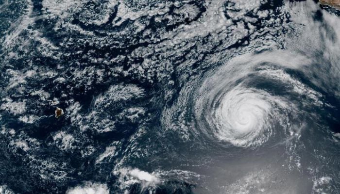
Hurricane Fausto is continuing to move across the Central Pacific as a Category 2 hurricane as of Friday, July 24, 2026.
According to the latest forecast by the National Weather Service, the system is predicted to get weaker before making landfall at Hawaii early next week.
Hurricane Fausto was far from land, about 1,385 miles east of Hilo, Hawaii, with wind speeds of 105 mph.
“The main impacts are going to be winds,” said National Weather Service meteorologist Matthew Fister.
He added, “It’s definitely going to bring a lot of moisture, higher humidity and rain. So that’s going to be the biggest impact, flooding…and surf on east-facing shores.”
Hurricane Fausto’s earliest landfall is expected to arrive on Tuesday, July 28, with the storm most likely arriving Tuesday evening at its current pace.
The emergency officials are warning citizens to stay ready in full preparation.
The Honolulu Department of Emergency Management says it’s coordinating with state and county agencies to mobilise the resources if the storm affects the islands.
“We are coordinating with those state agencies, making sure the resources that need to be ready for the storm are in place and operational readiness is at its peak,” said DEM Director Randal Collins.
Collins cautioned the residents; no matter if the hurricane Fausto weakens in the days to come, the residents should get themselves prepared, adding, “Remember, the Kona low wasn’t a tropical storm, but we got heavy rain, wind impacts and various power impacts.”